St. Thomas, USVI
N 18.20.016
W 64.55.469
2021.02.02
 |
| Some folks having fun in Charlotte Amalie Harbor |
Today was a nothing day as we never got off the boat. We started as we usually do with a dissection of all the weather information we can assimilate. Then we found our various nooks to curl up with a good book or watch the boats coming and going. We did hear from Gerry and Nicky in Curaçao. They are snug in a harbor and barely aware of the 30 kt winds howling outside. They texted us from a restaurant where they teased us with the seafood meals they were eating and the drinks they were having on our behalf. Its on days like this, we miss them terribly.
St. Thomas, USVI
N 18.20.016
W 64.55.469
2021.02.03
 |
| A relatively empty Charlotte Amalie Harbor |
Trying to listen to the SSB for weather today was frustrating to the point where Dale eventually turned if off and consulted his weather via the internet and satellite telephone. Both are looking good for a Thursday afternoon departure.
Once the sun was dumping enough amps in the can, he turned on the water maker for a couple of hours. Then he turned the fuel polisher on for another hour and then jumped in the water to scrub the waterline. Considering we had the bottom painted just a couple of months ago, we were surprised that he found as many barnacles as he did. He climbed back on board and asked if I wanted to defrost the freezer. Not that I couldn’t use the help but at this point, I really don’t want to add anything more to the freezer. I still have tomorrow morning if I change my mind.
We finished the day by reading in our respective books. I’m reading State of Fear and he’s finishing up reading another Carl Hiaasen book. He chuckles from time to time, so he must be enjoying it.
At Sea
N 18.29.01
W 65.21.12
2021.02.04
Dale was finally able to hear the SSB weather report and it still looked good for a Friday departure. However, after consulting the satellite weather, we are still going to depart this afternoon so that we can arrive in Mayaguana in the morning on Monday.
We secured the loose items before heading into town for a quick trip to the supermarket, picked up a couple of sandwiches from Subway for the road (so to speak) and ate chicken sandwiches at Wendy’s for lunch. After that it was back to the boat, so that I could put everything away and Dale could secure the dinghy. We still had 2 hours to kill, so Dale put on a Scop patch he had found and laid down to check for light leaks behind his eyes. I finished my book and uploaded some photos to the blog.
 |
| Sail Rock |
We hoisted anchor at 2:53 and by 3:15 we were sailing in light air. I snapped a photo of Sail Rock and sent it to our kids asking if they remembered what it was. We used to ask them when they were younger what its name was every time we passed it when we were stationed down here in the early 90’s. Some remembered, some didn’t.
As predicted, the winds continued to abate and soon we were messing around with the Code Zero for light air. Even it kept collapsing in the 5 kts breezes, so we furled it in and turned on the iron genny. We had left our main up but centerlined just so that we looked nautical.
Dale had the 4-8pm watch when we saw some clouds on the horizon at dusk. We debated as to which direction they were going but as dark enveloped us, it was pretty hard to keep track. We decided that they must indicate the front that we had been waiting for passed. About 6pm things shifted dramatically. Our 5 kt winds started to pipe up and quickly at that. We had just made the decision furl away the jib and to put a reef in the main when we saw the first 30kt gust on our anemometer. About 45 minutes later, we put a second reef in when the 30kts were no longer gusts but a constant push from behind. We’ve always said that we were going to mark the halyard at the cleat as to where the 1st and 2nd reef points were going to be for when you can’t see the sail. Too bad it was just good intentions. Of course, by now it was pitch black (naturally). It’s still a good idea but we managed to reef the sail to about a 1/3 of its normal size when we were able to check. In any event, we still were trucking along at 5.5-6 kts. The boat seemed to be doing well, so we weren’t concerned. This went on for 2 hours; I was grateful that Dale had found a Scop patch and that he was feeling well throughout the ordeal. Then just as quickly as it had come upon us, it was gone and we were back to motoring in 5 kt winds.
Lastly, during the night, I spotted a blinking yellow light that seemed to line up with a light depicted on the chart. However, as the night progressed, the single light became 3 lights though they didn’t appear to be moving. Finally, the AIS indicated a boat in that location. It wasn’t moving and reflected that it was not under command but it was also in over 1000’ of water. When Dale came on watch, I pointed it out and told him what I had learned. We think it might have been an oil derrick although I wasn’t aware that Puerto Rico had derricks around them now. It was the only contact I had, so that’s why I’m telling you about it.
At Sea
N 19.31.94
W 67.03.79
2021.02.05

Can’t say much happened today. Dale’s walk about found another kamikaze flying fish and lots of ink marks but no octopus body, so that one must have slipped overboard already.
We hoisted the Code Zero for a while. When the winds went too light, we furled it back in and turned on the engines for a while. When the winds filled back in, we turned off the engines and sailed wing and wing for a good portion of the afternoon but by evening, we brought the jib in to the center and sailed with just the main for the remainder of the night. We never saw any ships at all today and considered ourselves lucky when we were able to identify two planes flying miles overhead. At least we assured ourselves that we weren’t all alone in the world.
One really cool observation were the stars. I think the middle of the ocean is probably the best place to see the stars anymore. Tonight was totally clear and the stars were amazing. I remember my dad pointing out the big and little dippers to me as a child on a farm. This evening it took some time to identify them as there were so many, you had to be careful.
At Sea
N 20.48.671
W 69.11.604
2021.02.06
Today’s walk about did not locate any flying fish right away but later when I was looking out the back, I found one in the dinghy. So, I’m calling it today’s fish. So far, we haven’t missed a day.
 |
| Wing & Wing & Wing! |
We sailed the entire night and whole day; no engines! In fact, once the sun rose, we sailed wing and wing and wing (both the Code Zero and jib plus the main centerlined) until the sun set again. I’m sure if anyone saw us they must have wondered what in the world we were doing. It worked, so who cares?
Dale ran the water maker a couple of hours today and climbed up on the hard top to unkink our main sheet. He also created a type of preventer to keep the main boom from rocking back and forth with the waves, so he had something interesting to do.
We did see 3 ships today. All 3 were 5+ miles away so AIS barely picked them up. One’s info indicated that it was bound for Jacksonville. We assumed Jacksonville, Florida and toyed with the idea of trying to hitch a ride to the east coast.
When Dale checked the weather today, it appears to be holding and we’ll have smooth sailing until the middle of the week. We’ll try to get as far as we can, while we have the window. Other than that, we’re making steady progress with speeds up to 8 kts.
At Sea
N 22.04.707
W 71.35.577
2021.02.07

Another beautiful day with light winds and abating seas; unfortunately, that also means we had to turn on the engines about 4pm. It also might be the reason we didn’t have a fresh fish catch of the day although we did see squadrons of flying fish throughout the day. We made our waypoint to the northeast of the Turks and Caicos about 11pm and turned further west to head toward Mayaguana at the southern end of the Bahamas.
At Sea
N 22.46.244
W 73.31.076
2021.02.08
Another beautiful day. Today’s weather indicated the window was lengthening a bit and as we had become accustomed to our sleep routine while underway, we decided to use the perfect wind and seas to continue on when we made our Mayaguana waypoint by noon. With just a tweak here and there we continued to sail wing and wing with the Code Zero and the jib while rounding slightly toward Samana. However, due to the decision to continue on, I was forced to cook while underway. Generally, I’ll pre-prepare meals so the only thing needed is to reheat them. This time, I was slicing and dicing and having to keep an eye on a knife that seemed to sprout legs and take off every time I laid it down, plus since I’ve removed my pot stabilizers from the stove, I was constantly having to chase my pot around the stove to keep it over the burner. I thought of Nicky having to do this for 22 days when they cross the Pacific. I do not envy her in this respect; I found it very challenging at best.

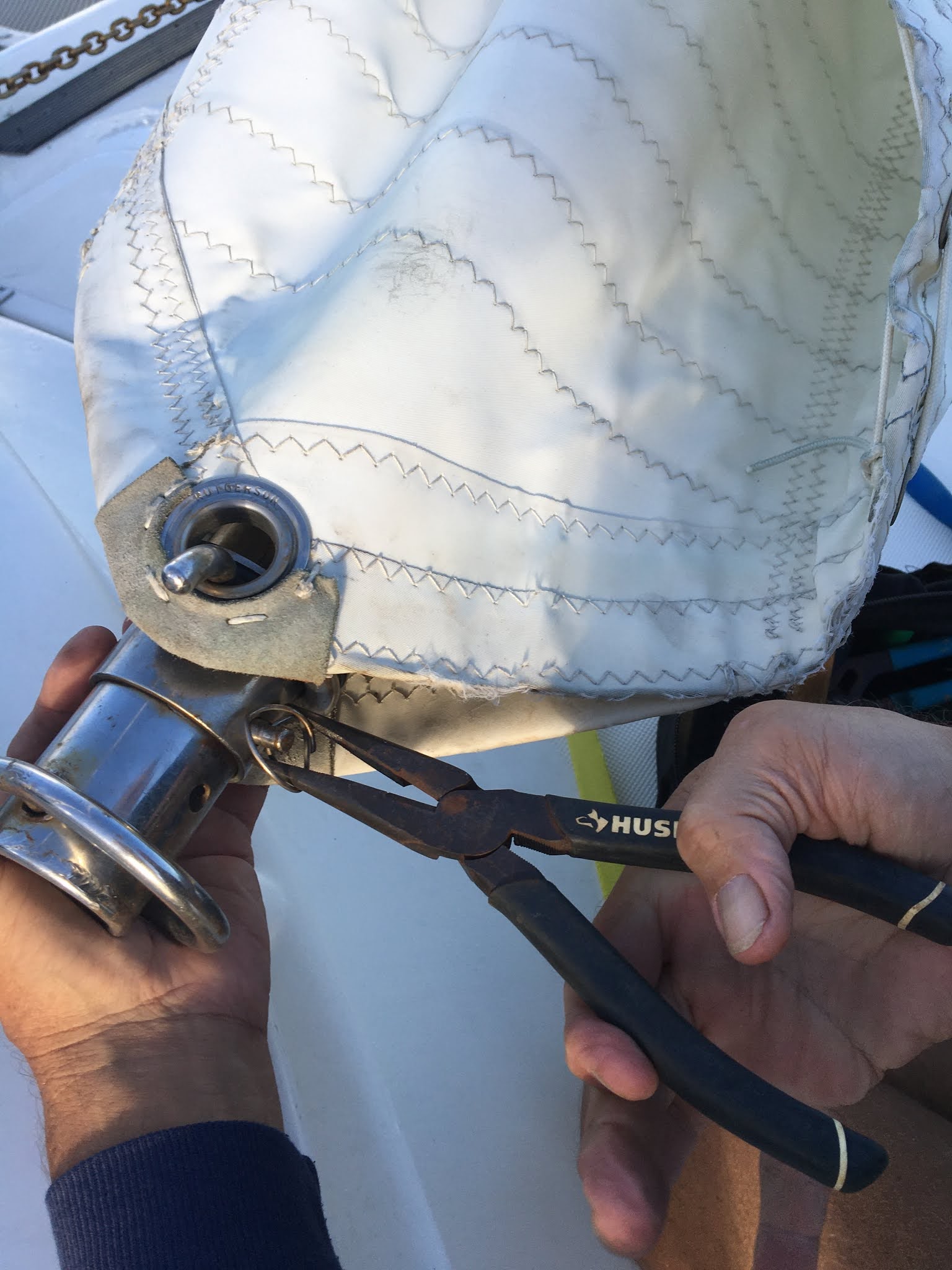
Another item today was that Dale had to perform underway repairs. During his walk about, he found on the deck a rather substantial ring used to keep screws, bolts, etc from backing out of where they belong.He picked it up, put it in his pocket and then tried to locate where it had fallen from. Most rings of this nature are on our life lines but this one was a heftier version thus, most likely, more important. Not finding anything right way, he slept on it; literally. Not the ring; the issue. After his rest period, he got up walked up to the jib, checked the end and sure enough, that’s where it belonged. Next I see him using the pair of pliers he had taken with him to hammer something. So I went below and grabbed a couple of hammers for him. Right about the time I came back up, he came back to the cockpit and selected the biggest one I had managed to find. I remembered the last time he and Gerry and tinkered something with the big hammer and hoped it wouldn’t result in the same outcome. He finally came back and announced that although he couldn’t get the pin through far enough to secure the ring through it, it was so wedged in place, it wasn’t going anywhere. He did caution me though, not to let the jib flail back and forth too much.
By 7:30 in the evening, we passed Samana and headed to our next waypoint at Rum Cay.
At Sea in the Exuma Sound
N 23.54.383
W 76.16.572
2021.02.09
In the wee hours of this morning we passed a container ship named Cosco Fortune heading for the Panama Canal (at least that’s what it’s AIS identification said). We swapped sides with our sails, made a slight course change and passed Rum Cay about 7:30am but still sailing wing and wing. Not exactly sure why this always makes a difference but it allows us to pinch higher on one side versus the other while sailing wing and wing.
By 8am, Dale was back checking the jib making sure the pin hadn’t fallen out and decided to try to secure it again as it was looser now that it had wiggled thoughout the night. Out came the big hammer once again. This time, it worked. He was able to align the pin, push it through and secure the ring back into the hole of the pin where it lived.
After that, another beautiful day of sailing wing and wing over the Exuma Sound. Instead of taking our previous course of hugging the islands, the wind was more favorable to make a straight course across the Sound. It cut off a few miles and Dale was hoping that we could make our landfall of Cave Cay before nightfall.
If you’ve followed this blog long enough, you’ll remember that this is where the SHTF about Christmas time a year ago. To enter Cave Cay Cut, you have to negotiate a narrow, rocky edged, swift current channel with a sharp 90* turn at the end. Best done during daylight hours. Well . . . guess what? Not today. We ran out of daylight about a hour and a half before reaching the waypoint. To continue on to the next cut would have us entering an unknown channel in the wee hours of the morning. We decided that if nothing else, we knew this cut too well. We furled the sails and turned on the engines several miles out, they continued to run without issue and when the time came to enter, Dale took a position on the bow with a high powered spot light. I took my position at the helm with my eyes glued to the chartplotter. Tonight’s situation had us entering through an outgoing tide with the wind perpendicular to us. Nothing but fun! I kept our forward speed over ground between 3.5-4 kts although to do it, I had to keep our boat’s speed at 6+ kts due to the current. I followed the chart plotter’s magenta line showing the suggested course while Dale would direct me either left or right due to what he was seeing. Since you’re reading this, you know that we survived.
We rounded into the channel between the islands and motored over to where we had anchored previously. However, Fate was not done with us yet. Now that we’re back in the Bahamas, we needed to reset our depth pucker gauge. We were now anchoring in water that reflected 5-6’ on the chartplotter instead of the 20-30 feet we had become used to in the southern Caribbean. As I nosed us into where we had previously been, Dale tried to lower the anchor, only to have it jam. During much sailor speak, he directed me to hold us where we were, so that he could free the jam. It only took 10 minutes in the pitch black with a head lamp on but it seemed to be an eternity back at the helm. I’d hear things fall; sailor speak; chain shift in the anchor locker; sailor speak; attempt to run the windlass; sailor speak; but eventually, I heard him say “lets try this again”. When he let the chain out, it sounded like he let out half our allotment. Normally, I’m the one who wants lots of chain. This time I was concerned that we’d be hanging our stern out in the channel. There was no one around, so we decided to leave it.

When he came back to the cockpit, he showed me a piece of coral entwined with string that somehow wedged itself in one of the chain links. When we tried to run the chain through the gypsy, it jammed the gypsy. Dale had to disassemble the gypsy to dislodge the coral, put the gypsy back together again before trying to run the chain through it. As I’ve said many times, I wouldn’t be out here if I didn’t think he couldn’t fix just about everything on this boat. Which is good. Since while he was up there working in the dark, he saw that one of our running lights has decided to take the rest of the time off.
For the time being, once again, we have a firm grip on Mother Earth.
Staniel Cay, Exuma, Bahamas
N 24.10.889
W 76.27.63
2021.02.10
One of the first things we had to do today was reset our clocks. We’re not sure when we passed the time change but considering we didn’t want to disrupt our watch schedule, (because we each have to stand our allotted time on watch!!) we left it until today. So bright and early, as the sun was up, but we’re not real sure what time it was, we were underway. Dale commented as we left that we couldn’t have anchored more perfectly the night before had it been daylight. We’re also guessing that we had 120’ of chain out for 5’ of water as our freshly painted lengths seem to have disappeared.
We sailed, you guessed it, wing and wing up to Staniel Cay and weaved our way through the shallows and coral heads to the Staniel Cay Yacht Club. It had really grown since we last saw it in 2005. We were advised to stand off until the two small boats finished fueling and then motor in when they left. This we did. Until one of the small boats left and another took its place. We radioed in again, telling them that we were still standing off waiting but this time we positioned ourselves crosswise of the channel, so that boats only had room to go around us and it was quite obvious that we were waiting to refuel. Regardless, another large powerboat tried to nose its way in but Dale was on the bow, with hands on hips, when the other boater decided to circle around and get behind us. Smart decision.
Once, we were finally able to tie up and refuel we were pleasantly surprised that we only needed 40 gallons diesel and only 5 gallons water. (If you’re keeping track, that’s 60 gallons diesel since we left Grenada). Dale had been running our watermaker for a couple of hours here and there during quieter times sailing with solar power or if we were motoring during quiet seas. We were really happy with that.
After we were topped off, we pivoted out, made our way to the anchorage by Big Major island and anchored behind another Manta. I about lost it when Dale got on the radio to them and not only told them that we had just arrived in from St. Thomas but where we were from, what our address was in the States and to come on by after they were done with their PCR tests. On the surface you’re probably wondering why I’d be upset. I’m married to a gregarious, friendly sort of man who knows no stranger; this I know! However, we are in a CoVid transient status while traveling through the Bahamas: we can rest, refuel and repair but cannot go ashore; and I would say that would include not having people over to our boat and announcing this to the whole world. We are allowed this in exchange for not having to check in, have the visitor PCR test or subsequent 5 day quarantine. We are transiting the Bahamas as quickly as possible! Do not STOP and collect $200! UGH!!!
What was done was done. So I went back to my tasks of making more meals for the road. Chicken casserole, taco meat that could be microwaved and jambalaya for those chilly nights I have been warned are coming our way and Dale worked on fixing the errant running light by stripping the corroded wires back to good wire and reconnecting it.
Afternoon came and sure enough, Jennifer and Royce from S/V Cerca Trove dropped by for a visit. Before they got off their dinghy we warned them that we were in a transient status and had not had any PRC tests in the last 2 weeks. They laughed, said they didn’t care and climbed aboard. Well, alright then, welcome! We had what turned out to be a great visit. Jennifer would rival Dale for his outgoing personality. We compared CoVid stories; they won. They were really interested in the changes we had made to our boat and we promised to send photos if they needed them in the future. They also said that they knew of a couple who might be interested in purchasing a Manta. That’s wonderful ours is going up for sale as soon as we can clear our stuff off. We exchanged boat cards and hopefully we can make a connection with the people they knew when we get back home. The other couple live in Pensacola, so it shouldn’t be too much of a problem. I apologized to Dale for being so paranoid, it was a good visit; he admitted that as the words were coming out of his mouth, he had second thoughts about what he was saying.
Later that evening, Dale checked his electrical handiwork. No joy. The running light still isn’t working. He has a spare, so that’s a job for tomorrow as we plan on another island hop before we do an overnight transit across the bank. Thankfully the weather is holding but a front is pressing down from the States on Sunday, so we may get stuck behind either Gun or Cat Cay before jumping over the Gulf Stream. We’ll keep an eye on it.
Highborn Cay, Exumas, Bahamas
N 24.43.017
W 76.50.034
2021.02.11
We hoisted anchor this morning at 7:45 and headed north along the islands to Highborn Cay sailing once again, wing and wing or with the wind behind us when we weren’t. We were flying; seeing between 6.5-8.5 kts! We were fascinated with all of the boats and really big boats that are here in the Bahamas. Some of the charts’ “magenta lines” were like highways as dozens of boats headed south. There are a few of us heading north but it was incredible the numbers we were seeing. The anchorages are filled but with the depths of the water rarely over 15 feet, boats can anchor pretty much as far out of the anchorages as they want. Just keep well lit so that others can see you.
As we entered Highborn Cay anchorage, we found a spot far enough away from another Manta that Dale couldn’t see the name of it. We were anchored by 2:30pm and he set about putting together the new running light that he was going to replace the old one with. Unfortunately, due to where it’s located, we needed to empty out the forward lazarette so that he could crawl down inside to run new wires. Then we wrapped a folding chair around the outside of the seat in the bow where the new light would be mounted so that he could heat shrink the connection without the flame going out.
Next on his list of fun things do was changing the fuel filters on the two engines. As both filters were black, it was a good thing as we all know that as soon as its dark, entering into a new, narrow, harrowing area, they are bound to choke up and ruin a perfectly good day.
At Sea
N 24.56.025
W 77.35.112
2021.02.12

What a miserable night. Rocking and rolling with the wind blowing a hooley. We finally let out more chain to where we had out 125’ just to be on the safe side.
Dale tried to listen to Chris (weather guru) on the SSB but finally gave up and consulted his satellite weather info. We reviewed our charts and decided to go to the south of New Providence and cut across to the bank via vectors meant for the big boys. Although it would require another overnight passage to reach Gun/Cat Cay, this ended up being a great decision. We sailed wing and wing with the Code Zero and made 6-7 knots all day. What a beautiful day! When the wind finally died, we rolled in the Code Zero and turned on the engines at about where the NE Channel marker is. We continued on throughout the night making good time.
At Sea
N 26.11.211
W 79.34.33
2021.02.13
We’re back in the Gulf Stream! Morning found us approaching Gun/Cat Cay and saying hi to another fellow Manta (S/V Hahalua) as they passed us heading south. We told them of the other Mantas in the Bahamas and wished them well on their journeys. We threaded our way through the cut between the two cays and made our way out onto the shelf before the Gulf Stream to turn into the wind and put up the sails. Unfortunately, this is when the Code Zero decided to tangle its sheets around the drum at the bottom. What a mess! First we turned up wind to try to detangle the lines, then we had to turn down wind to clear the second line, finally when they were both cleared, we turned back up wind to let out the main sail before returning downwind the direction we were headed. Anyone looking at us must have thought we were nuts! Then, we ended up motor sailing as it there was no wind to help push us along.
Ft. Pierce, FL
N 27.28.018
W 80.19.721
2021.02.14
We made it! In the wee hours of the morning our GPS lost its fix and it took a couple of reboots to finally get it to acquire its location again. At this point we’re paralleling Florida so all you have to do is turn left, pull in somewhere and ask directions but still, the whole idea is to know where you are in case of emergencies. We have several backups and paper charts but I thought that these latest bog entries have been pretty boring, so yes! For a minute or two—we were lost!
Once we found ourselves again, we entered Ft. Pierce jetty a couple of hours later at about 4:30am and slowly made our way through the channel, past some boats I swear were swinging into the channel, dodged them before turning towards Harbortown Marina, our home away from home in years past. Unfortunately, all of the outside anchorages were full (at least they appeared to be in the dark), we tiptoed around everyone up to the bridge then about-faced and made our way back to the main channel before heading in the opposite direction under another bridge looking for a spot to drop the anchor until day break. We anchored about 5:30am in 8’ of water that didn’t appear to have any cables or entanglements across it. Once the sun came up, we called Harbortown, spoke to the security person and requested information on when the fuel dock would open. As luck would have it, by the time we made our way back to them, they would be opened. We pulled in and took 18 gallons. If you’ve been tallying our fuel consumption, we’ve used 78 gallons to travel from Grenada to Ft. Pierce. Amazing! We’ve been fortunate that the wind has been behind us most of the way. We were also fortunate in that they would allow us to stay on the fuel dock overnight.
After a couple of hot showers, we made our way to the restaurant where we had to belly up to the bar for lunch. I ended up sitting next to a man who was certain that he had spent some quality time with the bar tender previously but couldn’t remember her name. He provided some humor to our lunch. It was Valentine’s Day, so Dale made good on taking me out. After that it was back to the boat where we fell into bed for some much needed sleep. It was raining off and on throughout the remainder of the day, so there was no problem sleeping in what would normally would have been a very busy area. In fact, we can only think of 2 other boats that came in to fuel for the entire day and the second one also stayed to spend the night.
We finished the evening with a nasty thunderstorm that made its way through but we’re hoping the weather will clear up so that we can make it home quickly. We watched the weather on the news and it looks like another front passing through on Thursday night (4 nights from now), so we’d like to be tied up and safe before that passes by. It takes 3 days to transit via the Intercoast Waterway but only 2 if we go via the ocean route up the coast. We’ll have to wait and check the weather charts tomorrow morning; we can always stay another night.
At Sea, off Florida
N 28.10.14
W 80.19.41
2021.02.15
Where do I begin? Well, we checked the weather and made the decision to head out of Ft. Pierce first thing this morning. After fiddling around trying to get the GPS to acquire a signal again, we exited the fuel pier about 8am without any drama and made our way out of the InterCoastalWaterway to the channel leading to the ocean. We turned and raised our sails (keeping a good sized reef in the main sail) and with only a little hiccup when the jib retrieving line tangled. Once cleared, we turned back to our course and for the next 10 hours we had a delightful, non-eventful sail up the Florida coast until about 4pm when the wind died and we turned on the engines, furled in the jib but left the main sail deployed just to look nautical. Dale rigged a preventer to it to keep it from swaying from side to side as what little wind we had, was from behind us.
About 8pm we started seeing lightening coming off the coast to the North of us, the West of us and to the Southwest of us. As it was a good ways off, we just kept an eye on it and continued on. One cell passed in front of us and continued on its path to the Bahamas and another took its place in front of us. The one to the Southwest of us, grew to the point where it appeared to catch up to the one to the West of us but stayed pretty much on shore. Then all hell broke loose. Just before 11pm and change of watch to Dale, the wind started to pick up and shift to our left. Since the main was secured to the port side (left), I called to Dale and asked him to come up to take the preventer off. Generally, it takes him about 8 minutes to wake up, go to the bathroom, don his life jacket, and get ready. By the time he actually made it outside, the wind had clocked completely around to our bow, then minutes later completely to our right. The main was straining at its tether in 20 knot winds that were increasing steadily.
In order to take the strain off the preventer we turned into the wind and tried to bring the remainder of the main sail down. We had just about furled it back into the boom when the wind cranked up to well above 30 knots (Dale says he saw 40, I was too busy praying by this time, so I can’t confirm it) and right about then we heard a loud pop and we could no longer crank the main sail into the boom. As we had already brought the boom in as close to the centerline as we could without releasing the preventer, it didn’t slam as badly as a jibe but it did grab our attention. We figured that the reason we couldn’t finish bringing the main in was because if the sail doesn’t go in straight, sometimes it hangs up until you can raise it back up and bring it in square. It was pitch black and the only thing we could tell for sure was that the Manta insignia was the only thing still visible on the sail; in other words we had a slip of a sail still deployed.
In any event, we kept the Palace pointed into the wind until the cell had passed. Both of us were unnerved by the severity of the storm. We’ve been in nasty weather before but this was the first time we purposely turned into the wind and just stayed there until the weather had cleared. And then, it was gone. Back to nothing winds and calm seas and surprisingly, back in the direction we had just come. Once again, we did a 180 and returned to our original course.
This was not what had been predicted and we were discussing the fact that our weather guru rarely misjudges the severity of a storm often erring on the side of caution, when our next surprise had us running from side to side. Dale was the one facing the shore when he saw what appeared to be an explosion. Then we both watched as a rocket was launched from Cape Canaveral. In all of the years we’ve traversed this coast, we’ve never seen a launch from the water. To clarify a bit: there is an exclusion zone around Cape Canaveral that keeps boaters well off the coast and there is even a red lighted buoy that you are directed to go around to stay out of their way. This we had faithfully done. Even in the storm. Now, we watched as the rocket appeared to go over us. Then we felt the sound as it traveled above us. Just like on TV, we saw the 1st stage burn out, and the 2nd stage ignite. Amazing! Then it was gone. I was astounded that they would fire off a rocket with the lightening and storms I felt were everywhere. Apparently, there was a hole in the clouds and they shot right through it. We were so excited to be able to have seen this.
Then, all of the excitement was gone and the rest of the night returned to the normal transiting.
W 79.34.33
2021.02.13
 |
| Gun Cay Light House |
We’re back in the Gulf Stream! Morning found us approaching Gun/Cat Cay and saying hi to another fellow Manta (S/V Hahalua) as they passed us heading south. We told them of the other Mantas in the Bahamas and wished them well on their journeys. We threaded our way through the cut between the two cays and made our way out onto the shelf before the Gulf Stream to turn into the wind and put up the sails. Unfortunately, this is when the Code Zero decided to tangle its sheets around the drum at the bottom. What a mess! First we turned up wind to try to detangle the lines, then we had to turn down wind to clear the second line, finally when they were both cleared, we turned back up wind to let out the main sail before returning downwind the direction we were headed. Anyone looking at us must have thought we were nuts! Then, we ended up motor sailing as it there was no wind to help push us along.
Ft. Pierce, FL
N 27.28.018
W 80.19.721
2021.02.14
We made it! In the wee hours of the morning our GPS lost its fix and it took a couple of reboots to finally get it to acquire its location again. At this point we’re paralleling Florida so all you have to do is turn left, pull in somewhere and ask directions but still, the whole idea is to know where you are in case of emergencies. We have several backups and paper charts but I thought that these latest bog entries have been pretty boring, so yes! For a minute or two—we were lost!
Once we found ourselves again, we entered Ft. Pierce jetty a couple of hours later at about 4:30am and slowly made our way through the channel, past some boats I swear were swinging into the channel, dodged them before turning towards Harbortown Marina, our home away from home in years past. Unfortunately, all of the outside anchorages were full (at least they appeared to be in the dark), we tiptoed around everyone up to the bridge then about-faced and made our way back to the main channel before heading in the opposite direction under another bridge looking for a spot to drop the anchor until day break. We anchored about 5:30am in 8’ of water that didn’t appear to have any cables or entanglements across it. Once the sun came up, we called Harbortown, spoke to the security person and requested information on when the fuel dock would open. As luck would have it, by the time we made our way back to them, they would be opened. We pulled in and took 18 gallons. If you’ve been tallying our fuel consumption, we’ve used 78 gallons to travel from Grenada to Ft. Pierce. Amazing! We’ve been fortunate that the wind has been behind us most of the way. We were also fortunate in that they would allow us to stay on the fuel dock overnight.
After a couple of hot showers, we made our way to the restaurant where we had to belly up to the bar for lunch. I ended up sitting next to a man who was certain that he had spent some quality time with the bar tender previously but couldn’t remember her name. He provided some humor to our lunch. It was Valentine’s Day, so Dale made good on taking me out. After that it was back to the boat where we fell into bed for some much needed sleep. It was raining off and on throughout the remainder of the day, so there was no problem sleeping in what would normally would have been a very busy area. In fact, we can only think of 2 other boats that came in to fuel for the entire day and the second one also stayed to spend the night.
We finished the evening with a nasty thunderstorm that made its way through but we’re hoping the weather will clear up so that we can make it home quickly. We watched the weather on the news and it looks like another front passing through on Thursday night (4 nights from now), so we’d like to be tied up and safe before that passes by. It takes 3 days to transit via the Intercoast Waterway but only 2 if we go via the ocean route up the coast. We’ll have to wait and check the weather charts tomorrow morning; we can always stay another night.
At Sea, off Florida
N 28.10.14
W 80.19.41
2021.02.15
Where do I begin? Well, we checked the weather and made the decision to head out of Ft. Pierce first thing this morning. After fiddling around trying to get the GPS to acquire a signal again, we exited the fuel pier about 8am without any drama and made our way out of the InterCoastalWaterway to the channel leading to the ocean. We turned and raised our sails (keeping a good sized reef in the main sail) and with only a little hiccup when the jib retrieving line tangled. Once cleared, we turned back to our course and for the next 10 hours we had a delightful, non-eventful sail up the Florida coast until about 4pm when the wind died and we turned on the engines, furled in the jib but left the main sail deployed just to look nautical. Dale rigged a preventer to it to keep it from swaying from side to side as what little wind we had, was from behind us.
About 8pm we started seeing lightening coming off the coast to the North of us, the West of us and to the Southwest of us. As it was a good ways off, we just kept an eye on it and continued on. One cell passed in front of us and continued on its path to the Bahamas and another took its place in front of us. The one to the Southwest of us, grew to the point where it appeared to catch up to the one to the West of us but stayed pretty much on shore. Then all hell broke loose. Just before 11pm and change of watch to Dale, the wind started to pick up and shift to our left. Since the main was secured to the port side (left), I called to Dale and asked him to come up to take the preventer off. Generally, it takes him about 8 minutes to wake up, go to the bathroom, don his life jacket, and get ready. By the time he actually made it outside, the wind had clocked completely around to our bow, then minutes later completely to our right. The main was straining at its tether in 20 knot winds that were increasing steadily.
In order to take the strain off the preventer we turned into the wind and tried to bring the remainder of the main sail down. We had just about furled it back into the boom when the wind cranked up to well above 30 knots (Dale says he saw 40, I was too busy praying by this time, so I can’t confirm it) and right about then we heard a loud pop and we could no longer crank the main sail into the boom. As we had already brought the boom in as close to the centerline as we could without releasing the preventer, it didn’t slam as badly as a jibe but it did grab our attention. We figured that the reason we couldn’t finish bringing the main in was because if the sail doesn’t go in straight, sometimes it hangs up until you can raise it back up and bring it in square. It was pitch black and the only thing we could tell for sure was that the Manta insignia was the only thing still visible on the sail; in other words we had a slip of a sail still deployed.
In any event, we kept the Palace pointed into the wind until the cell had passed. Both of us were unnerved by the severity of the storm. We’ve been in nasty weather before but this was the first time we purposely turned into the wind and just stayed there until the weather had cleared. And then, it was gone. Back to nothing winds and calm seas and surprisingly, back in the direction we had just come. Once again, we did a 180 and returned to our original course.
This was not what had been predicted and we were discussing the fact that our weather guru rarely misjudges the severity of a storm often erring on the side of caution, when our next surprise had us running from side to side. Dale was the one facing the shore when he saw what appeared to be an explosion. Then we both watched as a rocket was launched from Cape Canaveral. In all of the years we’ve traversed this coast, we’ve never seen a launch from the water. To clarify a bit: there is an exclusion zone around Cape Canaveral that keeps boaters well off the coast and there is even a red lighted buoy that you are directed to go around to stay out of their way. This we had faithfully done. Even in the storm. Now, we watched as the rocket appeared to go over us. Then we felt the sound as it traveled above us. Just like on TV, we saw the 1st stage burn out, and the 2nd stage ignite. Amazing! Then it was gone. I was astounded that they would fire off a rocket with the lightening and storms I felt were everywhere. Apparently, there was a hole in the clouds and they shot right through it. We were so excited to be able to have seen this.
Then, all of the excitement was gone and the rest of the night returned to the normal transiting.
1 comment:
So are you home, or should I start fishing for y'all in the St Johns?
Post a Comment